Jul 31, 2008

Kampaengpetch>>Attractions

City Attractions


Kamphang Phet Historical Park

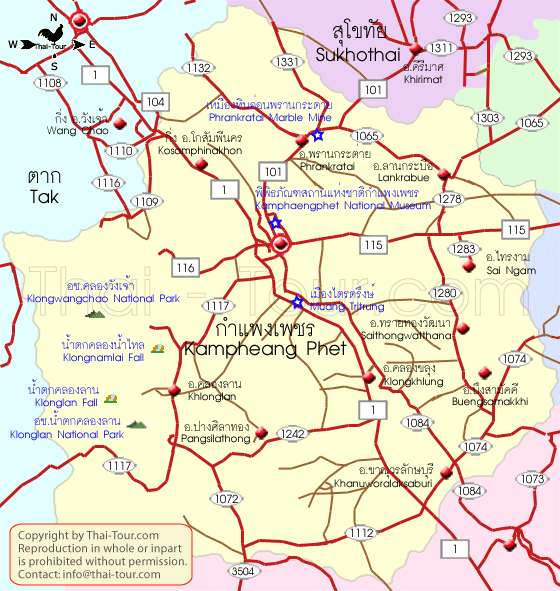
Major features in the Kamphang Phet Historical Park include archaeological remains of ancient sites such as Mueang Chakangrao to the east of the Ping River, Mueang Nakhon Chum to the west and Mueang Trai Trueng some 18 kilometres from the town to the southwest. Services from the Tourist Centre are available, the centre itself being located some 5 kilometres from town on the Kamphaeng Phet-Phran Kratai route.


Chakangrao, the ancient Kamphaeng Phet town, had the same town planning concept as the old Sukhothai and Si Satchanalai, with separate zones for religious sites both within and outside of town limits. Structures are usually large and made of laterite. Religious sites on the west bank of the Ping River at Nakhon Chum are built of bricks and of smaller


Remains of the ancient sites within the city walls are as follows:
City Walls and Old Fortifications mark the boundary of the rectangular town area, measuring 300-700 metre wide and 2,200 metre long.


Wat Phra Kaeo

Wat Phra Kaeo is a large royal temple in town centre near a site believed to have been a palace. The temple itself was used on important city events and had no monks in residence. Major features include the principal Chedi with lion-adorned base and a round Chedi with elephant-adorned base. There are also other Chedis of different bases and remains of several chapels. Its boundary is marked off by laterite walls.


Second in size to Wat Phra Kaeo is Wat Phra That. Here the principal Chedi is built of mixture of laterite and bricks with a 15-metre wide square base. The style is of Kamphaeng Phet architecture.

Sa Mon is the site of the palace located to the north of Wat Phra Kaeo with a square earthen wall almost touching the northern city wall. Surrounded the walls on three sides are moats with a pond in the middle. There are no standing structures remaining today.


Wat Phra Non

Wat Phra Non is fenced in by laterite walls on four sides. At the front of the temple are a square-shaped pond, bathrooms and an ancient floating pavilion which is supported by a large laterite column. The entire column was cut out in one single piece from its source and measures 1.1 meters on each side and 6.4 meters in height, the largest such stone in the country. A lion sculpture and Sema stones (boundary stones) can still be discerned. The large Vihan which once housed the Reclining Buddha has crumbled entirely.


Wat Phra Si Iriyabot

Wat Phra Si Iriyabot is located to the north of Wat Phra Non and have similar pond and bathroom facilities as its neighbour. Walls on the four sides are of laterite materials with an entrance also made of laterite. A Mondop structure houses Buddha statues in four postures-walking, sitting, standing and reclining in the Sukhothai artistic style. Today only the statue in the standing posture still remains.


Wat Phra Sing


Wat Phra Sing is believed to have been constructed during both the Sukhothai and Ayutthaya periods. With laterite walls, it has a square-shaped principal Chedi with arches on four sides. In front of the Ubosot are ornamental lion and Naga figurines.


Wat Chang Rop

Wat Chang Rop is a large temple situated on a high hill. Its main chedi of Ceylonese style is in the middle of the yard but its top part is broken down. The base is adorned with 68 half-elephants between which are Bhoti-shaped designs. There are also traces of demon and female dancers figures remaining.Apart from these temples, there are also several ancient sites on the east bank of the Ping River, including Wat Arwat Yai, Wat Kalothai and Phra Ruang Road.


Mueang Nakhon Chum is an ancient town on the west bank of the Ping River. Its 2-3 metre-high earthen walls run along the waterway. It is in this area that the famous religious tablets of Kamphaeng Phet have been discovered. Within the city walls are a couple of ancient sites such as the Kamphaeng Pom Thung Sethi located on Phahonyothin Road just before entering the town. It is part of the laterite fortifications 83 metres long and 6 metres tall.


Wat Phra Borom That is a temple situated in the centre of Mueang Nakhon Chum featuring a Burmese-style Chedi. To the south is an Ubosot housing several Sukhothai- and Ayutthaya-style bronze Buddha statues. The Chedi itself is believed to originally have been a Sukhothai-type structure, its style having been altered during a restoration work financed by a wealthy Burmese about a century ago.
Another ancient town is Mueang Trai Trueng. It was built by King Chaisiri of Chiang Rai who fled invading enemy in 1542 B.E. (circa 999). Today most of the structures are in disrepair with only ruins of Chedis and ramparts. The town is about 18 kilometres from Kamphaeng Phet on the Kamphaeng Phet-Khlong Lan road.

Talat Kluai Khai

This market is on the Kamphaeng Phet-Nakhon Sawan highway at Km.343. Scores of roadside stalls display and sell both raw and ripe Kluai Khai (a type of bananas).


The Kamphang Phet National Museum

The Kamphang Phet National Museum, located on Pindamri Road in Mueang district, houses ancient objects and other antique arts articles from various eras found in the provincial town. These include sculptured and earthen designs, heads of Buddha statues, traditional celadon products, sculptures of demons and celestial and human beings used to decorate Chedi bases or Vihans. It is open Wednesday-Sunday from 9.00 a.m.-4.00 p.m. More information at Tel: 0 5571 1570.

The Kamphang Phet Province Museum

The Kamphang Phet Province Museum nearby is made up of groups of Central Region applied architectural style structures. There are exhibitions on the local history with replicas of the city, lifestyle and urban and hilltribal customs and traditions. It also displays the development of Kamphaeng Phet votive tablets and other resources. The museum is open daily. For more information, call 0 5572 2341.

Klong Lan

Khlong Lan National Park


The Khlong Lan National Park covers an area of some 300 square kilometres over mountain ranges to the west of the province. The highest peak is about 1,400 metres. Of mainly virgin jungles, it is the source of several streams which flow into the Ping River.


The park headquarters is near the Khlong Lan waterfall about 60 kilometres from town on the route to Khlong Lan district (highway no.1117). Attractions within the park include the 95-metre high Khlong Lan Fall with scenic surroundings, and the Khlong Nam Lai Fall, a 9-level cascade and located off Highway no.1117 at Km. 35 and 10 kilometres further on). The Kaeng Ko Roi (off Highway No.1117 at Pong Nam Ron intersection) is a group of rock formations jutting out of the stream looking somewhat like all islands. Visitors can camp overnight within the park.


Mae Wong National Park
The Mae Wong National Park forms the border between Kamphaeng Phet and Nakhon Sawan and covers an area of about 894 square kilometres. Most of the land is rich in various types of plants. Along the Khlong Lan -Umphang route passing through the park's area, which leads up to the mountains, are several viewing points between Kms. 81 to 115. At Km. 102 is a beautiful road-side waterfall. Other falls within the park include the Mae Krasa, Mae Liwa and others. To visit these attractions tourists need to go on foot and overnight in the jungle.

by : thai-tour.com


Kampaengpetch>>Introduction

Introduction


Geographically located in the Lower North on the bank of the Ping River, Kamphaeng Phet is 358 kilometres from Bangkok. To its East are riverine flatlands while the western areas are made up of high mountains lush with fertile forests where a number of national parks have been established.


Areas along the river bank at present-day Mueang district used to host several ancient towns which had played a major role as strategic front-line frontiers since Sukhothai was the kingdom's capital down through the times of Ayutthaya and early Rattanakosin (Bangkok) eras. In fact, the name Kamphaeng Phet actually means as strong as walls or forts make of diamonds.


Kamphaeng Phet covers an area of 8,607 square kilometres. It is divided administratively into 9 districts, namely, Mueang Kampheang Phet, Phran Kratai, Khlong Khlung, Khanu Woralaksauri, Sai Ngam, Lan Krabue, Khlong Lan, Sai Thong Watthana and Pang Sila Thong and 2 sub-districts, Bueng Samakkhi and Kosamphi Nakhon.


How To get there


From Bangkok, take Highway No. 32 to Nakhon Sawan via Ayutthaya, Ang Thong and Sing Buri and then proceed along Highway No. 1 to Kamphaeng Phet, a total distance of 358 kilometres.


Both air-conditioned and non air-conditioned buses leave Bangkok’s Mochit 2 Bus Terminal every day. Call 0 2936 2852-66 or visit http://www.transport.co.th/ for more information.


by : thai-tour.com

Lumpang>>Attractions

Trip by Horse Carriage

The main horse carriages stands are in front of 1 the Old city Hall. You can ride a horse carriage northwards to Thipchang Road which used to be the central business road, at reach Thipchang Road and you will see Vihara of 2 Wat Khatuekchiangmun, installed by combining all the Lanna Vihara in Wat Khaturkchiangmun. The Vihara was constructed in the Lampang style temple architecture which emphasizes wooden vihara and tiered roofs.


Keep riding along Thipchang Road, turn left at the South Wang River to the end of the road and you’ll arrive at 3 Clock Tower . Many tourists are interested in taking pictures with horse carriages and Clock Tower. Go straight the Boonyawart Road, (Boonyawart was the name of the last Chao Muang (ruler) of Lampang.), you’ll see 4 Wat Suandok, built in 1947 A.D.The vihara was built in 1947 A.D. with exquisite interior decoration in Central style. Form Wat Suandok, the road continues to 5 Wat Boonyawartworavihara, at central Wiang. The old name was Wat Klangwiang. It was restored many times and was renamed. In 1915 A.D., this wat was changed into the original monument by King Rama VI. It was used in the ceremony for drinking the oath of allegiance which was the ceremony to show loyal.

Route 2: Around the Bank of Wang River

Start at 1 the Old City Hall, get a ride northwards (Northern Wang River) and cross 2 Ratsadapisek Bridge, built with concrete of the celebrated bridge in the reign of King Rama V. In 1950 A.D., the wooden and iron bridge was in disrepair and was restored as a concrete and iron bridge. The Kai Kau (white cock) and the Garude Luang symbol is placed on the pillar of the bridge. During World War II, the bridge was painted so that it would not be bombed.

After crossing Ratsaddapidek Bridge, turn left at the corner (Western Wang River) to Jarernprathes Road and go straight ahead for 500 meters and you will see 3 Witchanaree School on your right. Opposite the school is Saintword Hospital, built in 1931 (before World War II). Go ahead to the end of Jarernprathes Road, turn left and cross 4 Pattanapaknuea Bridge to Southern Wang River. Pass through the Khelang Nakhon Park and turn left to Thakhaunoi Road. Then turn left to Boonyawart Road, go along the road pass through 5 Clock Tower and return to Thipchang Road where you will see 6 Thedsaban Muang Lampang Park in the center of the crossroads. After riding to the Southern Wang River you will finally reach the Old City Hall of Lampang again.

Route 3: Around the Bank of Wang River to Tambon Soptui

Start at 1 the Old City Hall, ride eastwards on Boonyawart Road for 500 meters, then turn left and cross 2 Khelang Bridge to Northern Wang River, you will arrive at Tamaho Road. Go straight ahead about100 meters, turn left and you will reach Radpattana Road which was built in the period of teakwood trading with Myanmar. Many wooden houses were constructed and one of them was 3 Ban Saonak . Nak in the Northern dialect means Huge like many teakwoods. The huge teak is supported by 116 square teak pillars.

Go right to Jarernprathes Road, go straight ahead and you will reach the turning point. After you turn left at the turning point and cross 4 Ratsadapisek Bridge, you will arrive at the old China market which used to be the business area for Chiana people. Good were transported by boat through Wang River. You will see the ancient building, named 5 Kadkongta Buildings. It shows the prosperous trade around the bank of Wang River. Between Jarernprathes Road and Wianglakon-Wangkhar Road, you can see the view along the bank of Northern Wang River and Southern Wang River.

Along Wianglakorn Wangkhar Road before reaching the traffic circle, you will see 6 Ban Bombay on your right. The general officer of Japan, Chimo Naga, used to stay in Bombay House during World War II. After Japanese emperor signed to admit defeat in war, Thai government declared the peace and the Hara-kiri was made by Japanese generals in Lampang in order to show their loyalty. Then, go straight ahead and turn left towards 7 Thailand Radio Broadcasting Station. It was once Samosornlakorn Sport Club and was also a racecourse in the reign of King Rama VI and VII, Samosornlakorn Sport Club had once been the Japanese army situation.

Leaving Thailand Radio Broadcasting Station, go straight ahead and you will see on your right hand. After turning right into Thakhaunoi Road, After turning right into Thakhaunoi Road, you will see 8 Wat Srirongmuang, built in the 5th reign. At that time, Lampang was the central teakwood. This Wat was the one proceed route of the reign of King Rama VII in 1926. In World War II, the Burmese army had ever been in this Wat. Wat Srirongmuang was constructed in Burmese style which is noticeable in the wooden vihara’s rood and tiered roofs. The outstanding structure was exquisite, decorated with colorful mirrors and teak woodcarving by priming with black lacquer before covering it with gold leaves.

Next to Suren Road, through 9 Ban Praya Suren, who was the first governor of Lampang, The major industry on Suren Road was 10 the old sawmill. This sawmill had the wooden machine to transform wood and was once the place for an air raid warning. At present, Lampang Wanachai company has taken care of it. About 800 meters from the turning point on Suren Road, you’ll arrive at 11 Lampang Railway Station at Tambon Soptui. This station was opened on April 1, 1916 A.D. which was Thai New year at that period, and has been conserved as heritage until now. The main railway station of Lampang that connects with 3 of the northern railway routes, is at Tambon Soptui, Amphoe Maung. In accordance with the development of Lampang, the suburb area is developed to be urban area (Muang) and many buildings and houses are constructed.

..........................................................................
Lampang Reservation
by : thai-tour.com

Lampang>>Introduction

Introduction


Lampang is primarily known as Horse Carriage City “Muang Roth Ma” as horse carriages commonly seen by visitors portray people’s ways of life and their familiarity with them. At present, Lampang is the only town in Thailand where horse carriages public transport. Tourists can feel the liveliness as well as listen to the description about the historical sites in Lampang by horse driver.

In addition horse carriages, another real symbol of Lampang province hardly known by people is “Kai Kau” (white cock) which stands in front of the city gate as the emblem of Lampang. Moreover, the picture of “Kai Kau” is commonly found on signposts, bridges and old buildings. It has been retold that during Buddha period Buddha visited this province. When Indra knew, he was afraid that people would not get up in himself as “Kai Kau” to wake the people up. Lampang is therefore called “Kukkuk Nakorn” meaning “Kai Kau”. The sound “kikkuk” is similar to cock’s cry but the source if sound is originally unknown.


Historical Background


The northern region is the mostly agricultural. A great number of houses are built on either side of the river. Human settlement in northern Thailand were villages, small towns or large towns which were classified according to their degree of importance. The monastery or wat (temple) was the cultural center of the village. The village market (talad) met local economic needs.

Townspeople followed a wide range of occupations. Town was located near water and supported fairly large populations. Wiang was a kind of town which means an area encircled by walls and moats. There were two kinds of very small northern Thai towns. The first wiang was used as a defense position in times of unrest. In evidence, potsherds are seldom found at these sites, presumably because they were occupied for only short periods. The second wiang, wiang phrathat, served religious purposes. Some district or monasteries were formally designated as wiang the principal edifice of the monastery is the Phrathat. Year after year, villages pay homage to the Phrathat.


The large town was called “Nakhon”. These would usually be not one large wiang but an ordered group of wiang.The largest and most important would be the wiang of the capital Khelang Nakhon, also called Lampang, was the most important Muang in the northern Wang Valley. Evidence found from Wang Valley shows that in 680 A.D. Phra chow Arnantayod, was the first ruler of Kheland Nakhon with areas about 600 rai on the northern bank of Wang river of Wang Nuea at present. Phrachow Arnantayod was one of the twin sons of Phranang Jammatherwee, the ruling queen of Hariphunchai Kingdom.


Wiang Phrathat Lampang Luang is the most important religious wiang in the entire province. Wiang Phrathat Lampang Luang, 18 kilometers southwest of Lampang in Kao Kha District, is a roughly rectangular site. It is marked by remains of triple earthen walls separated by moats.


Local historical records give the name of one particular wiang as Lamphakappa Nakhon. There is a legend that the Lord Buddha visited this spot in his lifetime and predicted a fine for the province. Such as belief were once instrumental in ensuring the upkeep and restoration of a monastery.


Phrayah Muangrai established Kingdom of Lanna at the Kok River in the north of Kheland Nakhon. During the 13th century, he marched an army and seized with Kingdom of Hariphunchai. Finally, he occupied both Hariphunchai and Khelang Nakhon, which was under Kingdom of Hariphunchai and thus became the ruler. Until 1558 A.D. Lanna was a dependency of Myanmar for 200 years but sometimes it was under the Kingdom of Ayudhaya which was the strong domain in the south. On the time Kingdom of Ayudhaya was the strong domain in the south. The art objects were the trace of the extensive influence.


Myanmar occupied many towns in the North. The center rule was in Nakhon Chiang Mai. Until 1732 A.D., Taomahayod, the ruler of Hariphunchai, marched an army at Wiang Phrathat Lampang Luang and seized with Nanthipchang who was the hunter. Taomahayod was shot with a cannon at Vihara Luang by Nanthipchang. He became Lampang’s rule after he freed Lampang to be from Myanmar’s rule. After that, there was the coronation for Nanthipchang who won his crown by conquest.


The King Krungthonburi commanded Chow Ka wheela, the nephew of Nanthipchang to be Lampang’s ruler after Chow Kawheela cooperated with the southern people to seize with Myanmar. Later, Chow Kawsom, Chow Kawheela’s brother, Who was Lampang’s ruler after Chow Kawheela was promoted to be the ruler of Nakhon Chiang Mai.


In period of Chow Norranantachai Chawalit, the ninth ruler in the region of King Rama V in 1872-1897 A.D., Nakhon Lampang was a prosperous center of teakwood business on Talad Gao Road. Most owner of business was Burmese and lived in Tamaho community at Tambon wiang Nuea. Many monasteries in Burmese style were built in many places.


Phraya Suren Radchasena was the deputy in Lampang after Chow Boonyawartwongsmanit, the last Lampang’s ruler who died in 1922 A.D. He was the first governor of Lampang province in the reign of King Rama VI


According to technology development of aircraft, during World War II, the airplane named Lampang, was used in Lampang Airport at Amphoe Kao Kha. This airport was an important role to Japanese’s airbase. On August 14, 1945 A.D. the Japanese emperor signed to admit defeat in the war and Thai government declared the peace. After three days of the peace declearing, the Hara-kiri was made by Japanese generals in Lampang in order to show their loyalty. After the war was ended, many important and interesting places have remained until now.


Horse Carriage and Train


The horse carriages were only used as a mean of transportation in Lampang province during the reign of King Rama V. The first horse carriage was bought from Bangkok. Later, the horse carriages were wide-spread from Nakhon Lampang to Nakhon Ratchasima in the Northeast, Nakhon Si Thammarat in the South and Nakhon Chiang Mai, Muang Chiang Rai, Muang Phrae, Muang Nan and Muang Mae Hong Son in the North. Nowadays, the hourse carriages are still used in Lampang as a mean of urban transportation.


The wheeled vehicle in Lampang was found by Khun Uthankhadee in 1949 A.D., after 39 years of using horse carriage. In 1952 A.D., Chow Boonsong Na Lampnag changed the name of the wheeled vehicle to “horse carriage” in Lampang. At present, there are 70 horse carriages in Lampang and only 50 horse carriages provide service all day for the tourists to get around the town.

According to technology development, the outstanding development in Lampang was the railway station service. The first running train service from the northern route to Nakhon Lampang station, main terminal, was on April 1, 1916 A.D. in the reign of King Rama VI. Passengers were brought from Nakhon Lampang Station to Muang (town) by the horse carriage, called “Roth Ma Taxi”.

The main railway station of Lampang, that connects with 3 of the northern railway routes, located at Tambon Soptui, Amphoe Muang. In Accordance with the development of Lampang, the suburb area is developed to be central business district. After the railway route from Khuntan tunnel to Chiang Mai was built in 1921 A.D., Lampang has become the center of transportation. Goods are transported by the railway from Bangkok to northern and from the north to Bangkok by passing through Tambon Soptui. Therefore, Tambon soptui was fast prosperous and many buildings were constructed. Tourist can get the Roth Ma Taxi service to get around the town. The horse driver wear classic deluxe style cowboy outfit.

by : thai-tour.com

Jul 29, 2008

Chianmai>>Attraction

Amphoe Mueang

Wat Phra Sing

It is located on Sam Lan Road, this lovely temple dates from 1345 and is one of the focal points of Songkran festivities each April 13-15 when people bathe the revered Phra Phutthasihing Buddha image. The temple compound includes the lovely Lai Kham chapel with its exquisite woodcarvings and northern-style murals, and a magnificent scriptural repository with striking bas relief.

How to get there: From Thapae Gate follow Ratchadamnern Rd. straight to the end (west). Easy to walk.

Wat Suan Dok

It's built in a 14th century Lanna Thai monarch's pleasure gardens and is a favourite spot for photographers, particularly for striking sunsets. Several of the white chedies contain ashes of Chiang Mai's former royal family. Interesting are the Buddha Phra Chao Kao Tue, one of the biggest and most beautiful bronze Buddha images in Thailand.

How to get there: Take Suthep Rd. towards the mountain. 1 km approx. on your left hand side.


Wat Ku Tao

The temple is near the Chiang Mai Stadium. It is noteworthy for an unusaual bulbous pagoda. The structure is decorated with colourful porcelain chips and is believed to represent five Buddhist monk's alms bowls which symbolise five Lord Buddhas.

How to get there: Located on Chotana 4 Road. Along Phrapokklao Road at Phratu Chang Phuek, turn right, keep left, find a notice of the temple and turn left along a small lane.


Wat Chedi Luang


The temple is the site of an enormous pagoda, originally 280 feet high, and which was partially destroyed by an earthquake in 1545. At one time, Wat Chedi Luang housed the revered Emerald Buddha image now enshrined in Bangkok's Wat Phra Kaeo. One of Wat Chedi Luang's most striking architectural features is a magnificent Naga staircase adorns the chapel's front porch. The viharn houses a 9m bronze Buddha (made between 1438 and 1441). The huge tree not far from the entrance is believed to house the guardian spirit of the city, Lak Muang or Sao Inta Kin.

How to get there: From Thapae Gate, go West on Ratchadamnern Rd. and cross the first intersection. At the 2nd turn left (Prapokklao Rd.) Walk past Wat Phun Tao (recognizable by the huge wooden vihan). Chedi Luang is next to it.


Wat Ched Yod


The seven-spired square chedi was inspired by designs at Bodhagaya. Building started in 1455 under King Thilokanat to commemorate the 2000th day since the Buddha died. Example was the Mahabodhi temple in Bodh Gaya (India). Wat Ched Yod became a spiritual center of the first order under King Thilokanat. On the temple compounds there is also a big square chedi in Sukhothai style that contains the ashes of King Thilokanat.

How to get there: Located on Super Highway, north of the Huai Kaeo Nimmanhemin Rd. intersection. Before you get to the National Museum.

Chiang Mai National Museum

The museum houses a collection of Lanna Thai works of art, ancient Buddha images and war weapons. It is open daily, except Mondays, Tuesdays and official holidays, from 9.00 a.m. until noon, and 1.00 until 4.00 p.m.

How to get there: Located beside Wat Ched Yod, on the intersection of Nimmanhemin & Suthep roads, opposite the CMU Convention Center.


Chiang Mai City Arts and Cultural Center


Located at Prapokklao Rd., Tambon Sriphum. An old building of elegant architectural design was built in 1924. Standing on the location of former royal hall, the building was used as the central administrative offices of the Monthon Phayap administrative unit of Siam, and later as the Provisncial Hall of Chiang Mai.

The cultural center was created to help them understand their roots and foster a sense of pride in local indentity and thus to help preserve the beauty of local customs and culture. The museum has been divided into two sections. The front (eastern) part of the square-shaped building contains permanent exhibits. The rear section of the building has been dedicated to cultural activities, temporary exhibits, a souvenir shop, a lecture theatre, an exhibition hall for Lanna arts and an archive.

Permanent ExhibitsThe Permanent exhibits are thematically divided into periods and topics which are shown in 15 rooms. They show the development of the region and the city from pre-history to its rise and decline as an independent capital.The city's history is illustrated up until present times.The system of administration, way of life, local wisdom and the culture that have created the city's proud identity are presented using a variety of media . Models, slides, pictures with text explanations, digital video presentations and graphic displays will impress visitors and help them understand the origins of the city.

Temporary Displays and ActivitiesThe rear of the building and the enclosed open-air courtyard are reserved for a variety of cultural acitvities aimed at conserving and promoting the valuable traditions of the local culture.

Chiang Mai Zoo

Situated next to Huai Kaew Arboretum at the foot of the mountain where Phra That Doi Suthep is located, the zoo houses a pair of cuddly Pandas on loan from China. Inside the zoo, there are over 200 types of Asian and African mammals and birds for visitors to observe. Open daily from 8 a.m. to 7 p.m., the admission fee for an adult is 100 baht and a child is 20 baht. There are excellent facilities for tourists with restaurants and a camping site. Advance booking is required for large groups.

CMU Art Museum (Chiang Mai University Art Museum)

The Art Museum is situated on Nimmanhemin Road opposite the Chiang Mai University Auditorium. There are a lot of interesting exhibitions on display in the museum art gallery, check the schedule at the Faculty of Fine Arts, Chiang Mai University 239 Huey Kaew Road Chiang Mai 50200.

Doi Suthep - Doi Pui National Park

Covering an area of 262 sq. km., this luxuriant park is home to more than 300 bird species and nearly 2,000 species of ferns and flowering plants. Some hiking trails in the park pass Hmong villages while others lead to a few small waterfalls where local people come to picnicking on weekends. Accommodations are available near the park headquarters. To get there, take Highway No. 1004, its only 16 kilometers drive northwest of Chiang Mai town. The Park has interesting attractions, which include:

Wat Phra That Doi Suthep

Locals would say, You havent really gone to Chiang Mai unless youve been to Wat Phratat Doi Suthep. Truly, the place is the most important and famous Chiang Mai landmark. Built in 1383, this mountaintop temple has a chedi (pagoda) that houses holy Buddha relics. The gold-plated chedi lies in the middle of a square marble-tiled courtyard. The four corners of the chedi are adorned with parasols which represent royal regalia. The temples courtyard is lined by a cloister, which contains images and murals depicting Buddhas life. There are also two viharns situated in the middle of the east and west sides of the cloister. This temple is 15 kilometers from town and is 3,520 feet above sea level. It is the perfect place to get a birds eye view of the city. The temple can be reached via a steep Naga staircase comprised of 290 steps or railcars. The temple is open daily from 6 a.m. to 7 p.m.

by : thai-tuor.com


Chian Mai >> Introduction


Introduction


Chiang Mai is Thailand's principal northern province. It is some 700 kilometres north of Bangkok and covers an area of 20,000 square metres. The city is located in a fertile valley some 300 metres above sea level.

Chiang Mai was founded as the capital of Lanna Thai (Kingdom of One Million Ricefields) in 1296. It flourished as a major religious, cultural and trading center until 1556 when a Burmese invasion reduced it to a vassal state. The Burmese were expelled in 1785, whereupon Lanna Thai once again became part of northern Thailand.

Many lowland Thais regard Chiang Mai as being something of a national Shangri-la, thanks to its distinctive festivals, historic temples dating from the 1300s, arresting scenic beauty, temperate fruits and a crisp, invigorating cool season climate.

The people of Chiang Mai enjoy one of the most distinctive cultural identities in the whole of Thailand. Largely farmers and artisans, they have their own lilting dialect, their own indigenous handicrafts, their own dances and their own distinctive cuisine. Hilltribes also lend a great deal of character and color to the crisply beautiful mountanious landscape.

How to Get There

By Bus - The 10-hour journey from Bangkok can be made on air-conditioned coaches and non-airconditioned uses originating from the Northern Bus Terminal on Bangkok's Kampaeng Phet 2 Road (Tel: 936-3660} 937-8055)

By Air - Thai Airways (Tel:1566 or 280-0060) operated daily flights from Bangkok to Chiang Mai and flights from Chiang Mai to other northern Thai cities. Angel Air (Tel:953-1111) operates Bangkok-Chiang Mai and Chiang Mai-Udon Thani flights.

By Rail - The State Railways of Thailand (Tel:223-7010 or 223-7020) operates daily services from Bangkok's Hualumphong Railway Station including a popular overnight sleeper.

by : Thai-Tour.com

Jul 28, 2008

Welcome to Thailand


"Siam" redirects here. For other uses, see Siam (disambiguation).

The Kingdom of Thailand is an independent country in Southeast Asia. To its north lies Laos and Burma; to its east, Laos and Cambodia; to its south, the Gulf of Thailand and Malaysia; and to its west, the Andaman Sea and Burma. Its capital and largest city is Bangkok, called "Krung Thep Mahanakorn" in Thai. At 514,000 km² (198,000 sq mi) , Thailand is the world's 50th largest country in terms of land area, whilst it is the world's 28th largest country in terms of population.
It is comparable in terms of population to countries such as France and United Kingdom, and is similar in land area to France and California, United States. The Thai language is Thailand's official language, written in its own script, and 95% of Thais are Buddhists of the Theravada branch. The culture of Thailand incorporates a great deal of influence from India, China, Cambodia, and the rest of Southeast Asia. Like most Asian cultures, respect towards ancestors and elders is an essential part of Thai spiritual practices. Thais have a strong sense of hospitality and generosity, but also a strong sense of social hierarchy. Seniority is an important concept in Thai culture. Elders have by tradition ruled in family decisions or ceremonies.

Thailand has one of the longest monarchies in history. It is the only Southeast Asian country that was not colonized by any European power. A unified Thai kingdom was established in the mid-14th century. Thailand was known as Siam until 1939 when it was renamed. A bloodless revolution in 1932 led to a constitutional monarchy. In alliance with Axis during World War II, Thailand became a US ally during the Cold War. Thailand is currently facing separatist violence in its three southernmost ethnic Malay-Muslim provinces which border Malaysia.


Thailand exports an increasing value of over $105 billion worth of goods and services annually. Major exports include rice, textiles and footwear, fishery products, rubber, jewelery, automobiles, computers and electrical appliances. Thailand is the world’s biggest exporter of rice, exporting about 6.5 million tons of milled rice annually. Rice is the most important crop in the country; farming thus is the occupation done by most people of the country.


History


Main article: History of Thailand
See also:
Peopling of Thailand


The region known today as Thailand has been inhabited by humans since the
paleolithic period (about 10,000 years ago). Prior to the fall of the Khmer Empire in the 13th century, various states thrived there, such as the various Tai, Mon, Khmer and Malay kingdoms, as seen through the numerous archaeological sites and artifacts that are scattered throughout the Siamese landscape. Prior to the 12th century however, the first Thai or Siamese state is traditionally considered to be the Buddhist kingdom of Sukhothai, which was founded in 1238.
Following the decline and fall of the Khmer empire in the 13th - 14th century, various Buddhist
Tai Kingdoms of Sukhothai, Lanna and Lan chang were on the ascendancy. However, a century later, Sukhothai's power was overshadowed by the new kingdom of Ayutthaya, established in the mid-14th century.

After Ayutthaya fell in 1767 to the Burmese, Thonburi was the capital of Thailand for a brief period under King Taksin the Great. The current (Rattanakosin) era of Thai history began in 1782 following the establishment of Bangkok as capital of the Chakri dynasty under King Rama I the Great.
Siam retains an immemorial tradition of trade with its neighboring states and the cultures of the Indian ocean and the
South China sea. European trade and influence arrived to Thailand in the 16th century, beginning with the Portuguese. Despite European pressure, Thailand is the only Southeast Asian nation never to have been colonised. Two main reasons for this were that Thailand had a long succession of very able rulers in the 1800s and that it was able to exploit the rivalry and tension between the French and the British. As a result, the country remained as a buffer state between parts of Southeast Asia that were colonized by the two colonial powers.


Despite this, Western influence led to many reforms in the 19th century and major concessions, most notably being the loss of large territory on the east side of the Mekong to the French and the step by step absorption by Britain of the Shan (Thai Yai) States (now in Burma) and the Malay Peninsula. The loss initially included Penang and Tumasik and eventually culminated in the loss of three predominantly ethnic-Malay southern provinces, which later became Malaysia's three northern states, under the Anglo-Siamese Treaty of 1909.

In 1932, a bloodless revolution resulted in a new constitutional monarchy. During World War II, Thailand became an ally of Japan while at the same time maintaining an active anti-Japanese resistance movement known as the Seri Thai. After the war, Thailand emerged as an ally of the United States. As with many of the developing nations during the Cold War, Thailand then went through decades of political transgression characterised by coups d'état as one military regime replaced another, but eventually progressed towards a stable prosperity and democracy in the 1980s.

In 1997, Thailand was hit with the Asian financial crisis and the Thai baht for a short time peaked at 56 baht to the US dollar compared to about 25 baht to the dollar before 1997. Since then, the baht has regained most of its strength and as of 23 May 2007, is valued at 32 baht to the US dollar.

The official calendar in Thailand is based on Eastern version of the Buddhist Era, which is 543 years ahead of the Gregorian (western) calendar. For example, the year AD 2008 is called 2551 BE in Thailand.


by : Wikipedia

Chiangrai>>attraction

City

King Meng Rai the Great Monument

This is located on the city outskirts, beside the northern
road to Mae Chan, and honours the monarch who founded
Chaing Rai in 1262.


--------------------------------------------------------


Ku Phra Chao Meng Rai

Situated in Wat Ngam Muang, on Ngam Muang Hillock, this stupa contains King Mengrai's ashes and relics.


----------------------------------------------------------------

Wat Phra That Doi Thong

This ancient hilltop pagoda overlooks the Mae Kok River and predates the founding of Chiang Rai as the capital of Lanna Thai.


-----------------------------------------------------------------


Wat Phra Singha

This temple, on Singhakhlai Road, is a fine example of Lanna Thai religious architecture. The Phra Buddha Singh image now hourse in Chaing Mai's Wat Phra Singh was formerly enshrined here.

-----------------------------------------------------------------

Wat Phra Kaew

Formerly called Wat Pa Yia (bamboo forest), this is where the Emerald Buddha image was found. Thus the name of the temple was derived.


On 21 Oct 1990, Buddhist clerics and laity agreed to build the Jade Buddha (commonly called Phra Yok ChiangRai) to celebrate the 90th anniversary of the Princess Mother's birthday. The Buddha image was officially name Phra Phuttha Rattanakonnawuttiwatsanuson Mongkhon, which means the Buddha who is the source of gems.

In the main prayer hall tands a huge bronze Buddha image in the posture of "sub-duing mara, or demon". This is commonly known as Phra-Chao Lan Thong in Chiang Rai. It was transferred from Wat Phra Chao Lan Thong to this temple in 1961. The main hall itself was built in 1960 in the neo-Lanna style with double-tiered roof decorates with colored glass along the eaves and the beams. The front portal posts and gable are decorated with intricate golden patterns. The doors are showpieces of northern wood-carving techniques.


-----------------------------------------------------------------

Hat Chiang Rai

Located 5 kilometres from the city, this scenic riverside area and promenade is a recreation area for local inhabitants.

-----------------------------------------------------------------


Mae Kok River

Known in Thai as Maenam Kok, this scenic 130-kilometre long waterway runs through the heart of Chiang Rai. The river is a major transportation artery from neighboring Chaing Mai province, especially the town of Tha Ton (180 kilometres north of Chaing Mai provincial capital), whence tong-tailed boats make the 3-4 hour journey every day at 12.30 PM (Chaing Rai-Tha Ton: 10.30 AM). The river passes several hilltribe settlements and elephant camps from where jungle treks originate.

-----------------------------------------------------------------


Khun Korn Forest Park Waterfall

Located 30 kilometres south of Chiang Rai provincial capital, along Routes 1211 & 1208, the 70-metre high Khun Korn Waterfall is considered the highest the most beautiful in Chiang Rai.


-----------------------------------------------------------------

Chiang San

Ancient Town


This riverside town facing the Mekong River is 30 kilometres from Mae Chan via Highway No. 1016, predates Chiang Rai and is famous for a special style of Buddha image.


-----------------------------------------------------------------

Chiang Saen National Museum


This petite museum exhibits local objets díart, including Chiang Saen-style Buddha images and Lanna Thai artifacts. The museum is open on Wednesdays - Sundays from 9.00 AM until 4.00 PM, except national holidays


-----------------------------------------------------------------


Wat Phra That Chedi Luang


This ancient 88-metre high brick pagoda, next to the museum, is the tallest religious monument in Chaing Rai.
Built in 1291, this temple houses the biggest chedi in Chiang Saen. It is a bell-shapped chedi with an octagonal base. The main hall and other surrounding chedis have all fallen in ruins.


-----------------------------------------------------------------

Wat Pa Sak


Located outside the city walls, some 200 metres from the Tourist Service Centre, this deserted temple, with ornamental stucco motifs, is regarded as being one of the most beautiful examples of Lanna architecture in northern Thailand.
In 1295, Prince Saen Phu built this temple to contain Buddha's relics. He also had 300 teak trees planted in the temple compound.
Wat Pa Sak sits on 16 acre of land. There are 22 historic remains on the temple grounds. The main bell-shaped chedi has five tapering spires.
The chedi at Wat Pa Sak are considered to be the best physical condition as well as the most beautiful of Lanna Style. The pattern and design on the chedi reflect artistic development in Chiang Saen, revealing its original adoption of Sukhothai, Pagan (Phukam), and Hariphunchai artistric styles. Through the process of cultural transformation, a unique Chiang Saen style was realized. It has since become the prototype of Lanna chedis.

----------------------------------------------------------------

Wat Phra That Chom Kitti

This hilltop temple has a pagoda containing a Buddha relic.
This temple challenges it visitors to climb up 339 steps in order to admire its beauty. It is, however, also accessible by car. King Phangkharat had this shrine built to contain Buddha's relics. In 1487, Muen Chiang Song had a new pagoda built to cover the old pagoda.
Anothe pagoda containing Buddha's relics in the area is Phra That Chom Chaeng. A look-out point behind this pagoda offers a vantage point to enjoy the Mekong vista.


-----------------------------------------------------------------


Wat Phra That Pha-Ngao


Located 4 kilometres along the Chaing Saen-Chaing Khong road, this temples hilltop pagoda offers a spectacular view of the Mekong River and Laos.
Built uniquely on a big slab of solid rock, Phra That Pha Ngao is a relatively small bell-shaped pagoda. Another slab of rock stands in front of the pagoda as though it were the shadow. Thus derived the name "pha-ngao", meaning the rock shadow.
Initially, this temple was called Wat Sop Kham. Its former location was by Mekong River, and the temple was annually eroded by the tides. Townspeople thus agreed to rebuild the temple further inland by a deserted temple at the foot of Doi Kham. During the construction, they found under the base of the old Buddha image a magnificent Chiang Saen style statuette in subduing mara posture. After half of the Buddha image was revealed, the excavation was stopped and a prayer has was built to cover it. The image was called "Luang Pho Pha Ngao".


-----------------------------------------------------------------

Chaing Saen Lake


South of Chaing Saen, along Highway No. 1016 (a 2-kilometre trip from the Km. 27 marker), this one square kilometre lake hosts migratory waterfowl during the winter months. Birds are seen at their best and most plentiful from November through February.


-----------------------------------------------------------------

The Golden Triangle


8 kilometres north of Chaing Saen, this riverside area marks the spot where the borders of Thailand, Myammar and Laos converge.
This is the cross-roads of the three-land borders. The Ruak River bordering Thailand and Myanmar runs into the Mekong River from Laos creating the well known Golden Triangle. In the old days drug traffickers secretly met to barter off opium with gold nuggets. Today it is a bustling tourist destination where visitors
come to enjoy the rising sun emerging from the misty seas of fog.
For an aerial glimpse of the Golden Triangle, you need to climb uphill to Doi Chiang Miang by the Mekong River where Wat Phra That Doi Pu Khao once stood. Only a pile of bricks remains to mark the site, but it provides a look-out point to catch "the big picture" of the Golden Triangle.


-----------------------------------------------------------------

Mekong River Trips
Boats can be hired from Chaing Saen to travel upstream to the Golden Triangle, and downstream to Chiang Khong. The trip to the Golden Triangle takes some 30 minutes, the trip to Chiang Khong about 1 hour and 30 minutes depending on river currents and water levels.

There are several piers to board a river cruise. A six-passenger trip can cost about 300-400 Baht A long-distance cruise. which certainly costs more, can take you as far as Chiang Kong, Luang Prabang, Sip Song Pan Na , and even Khunming (South of China).

----------------------------------------------------------------

Wat Phra That Doi Pu Khao

This riverside temple near the Sop Ruak Market, offers a spectacular view of the Golden Triangleís riverine and mountain areas.

----------------------------------------------------------------

Mae Chan

Doi Mae Salong


Located some 40 kilometres from Mae Chan, along Route 1089, a mountaintop settlement known as Santi Khiri is home to descendants of Chinese Nationalist soldiers who fled to, and settled in Thailand, in 1940. Mountainside plantations of coffee, and fruit orchards, provide scenic variety. The area is particularly picturesque in December and January when Thai cherry trees are in blossom. Accommodation, restuarants and opportunities for horse - riding and trekking number among major attractions. 60 kilometres beyond Doi Mae Salong via Ban Thoetthai is Doi Hua Mae Kham where a large Lisu hilltribe village is located. During December, the area is dotted with yellow wild sunflower called Bua Tong


It is very famous among Thai people for years. Tourists of various generations have flocked here. Some fancy the Sakura Flower grown along the 2 sides of the road up to the hill. Many local tourist love fine weather here. Chinese food is widely cooked and served. When you are here, you should not miss taste Chinese Tea, at a food shop or Mae Salong Resort.


-----------------------------------------------------------------


Hot Spring
Located 8 kilometres from Mae Chan, along Route 1089, this complex has hot mineral water and bath-house facilities. Accommodation is also available.


-----------------------------------------------------------------


Hilltribe Development & Welfare Centre
15 kilometres along the route to Doi Mae Salong, the centre aids and administers local hilltribe settlements. Hilltribe handicrafts, including woven cloth and silverware, are on sale.


-----------------------------------------------------------------


Doi Saen Chai
5 kilometres beyond the Welfare Centre, this Akha hilltribe village can be reached solely by 4-wheel drive vehicles.

-----------------------------------------------------------------

by : Thai-Tour.Com

Chiangrai>>Introduction

Introduction

Chiang Rai province covers some 11,678 square kilometers with
a population of 1.23 million at an average elevation of 580 meters above sea level, Myanmar borders on the north, and Laos on the north and northeast. The provincial capital is 785 kilometers north of Bangkok. Chiang Rai was founded in 1262 by King Meng Rai and was the first capital of Lanna Thai (Kingdom of a Million Rice fields). The province contains Thailand's northernmost point at Mae Sai which is well known for its crisp mountain scenery, and hilltribes. North Chiang Rai and falls within the region known as the Golden Triangle, the area where the borders of Thailand, Myanmar and Laos converge.


90% of the whole area of Chiangrai comprises high mountains. Some are as high as 1,500 meters above sea level, especially those along the Phi-Pan-Nam Mountain Rang which come down from Daen-Lao Mountain in Chiangmai, stretching to meet Luang Prabang Mountain from Nan Province. Mt.Langka is the its highest peak at the height of 2,030 meters. Chiangrai, therefore, can boast of being the "motherland" of several important rivers that are the lifelines of the north. These include Kok, Ing, Lao, and Sai Rivers. Of these Kok River is the most important because its runs through the city of Chiangrai. Thus, you may hear... Kok Rafting.. in Chiangrai via Thaton, a district bordering between Chiangrai and Chiangmai. Staying at least a night during rafting.. accommoation is also available by the starting point...click Thaton Chale


How To Get There
By Bus The 11-hour journey from Bangkok can be made on air conditioned coaches and non-air conditioned buses originating from the Northern Bus Terminal on Bangkok's Kamphaeng Phet 2 (Tel: 936-3660 (or) 9378065 for further details).


By AirThai Airways (Tel : 1566 or 286-0060) operates daily flights between Bangkok and Chiang Rai.

by : Thai-Tour.Com